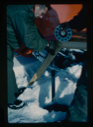
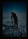
![Image of Nick Apollonio, Bowdoin College graduate, installs oceanographic equipment [Spencer Apollonio]](/media/Thumbnails/1992.27_kiosk/JPEG_flipped/1992.27.162.png)
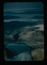
![Image of Independence Fjord intersects Bronlunds Fjord, glaciers and fjord ice [aerial]](/media/Thumbnails/1992.19_kiosk/JPEG_flipped/1992.19.112_flip.png)
Your current search criteria is: Keyword is "CIU".
View current selection of records as:| FILTER RESULTS | × Close |

 by Artist (39)
{blank artist}
115
Andre Operti
1
Benjamin B. Hampton
1
Carl D. Rutledge
15
Chauncey Waldron
6
Cook Publishing Co.
1
Daniel Trautwein
1
Donald Baxter MacMillan
149
Dunmore and Critcherson
3
Elliot Burwell
1
Emil Diebitsch
9
Frank Hurley
1
George Arthur Wardwell
1
Harry Whitney
8
Jakob Danielsen
1
James Rea
2
John Player and Sons
6
Kawin & Co.
6
M. & N. Hanhart
2
MacMillan, Donald Baxter
3
Marius E. Johnston
34
Matthew A. Henson
1
Maurice Cole Tanquary
25
Milton James Burns
2
Miriam MacMillan
3
Nestle Company
1
Paul Warren
1
Ralph B. Hubbard
2
Rutherford Platt
56
Rutherford Platt?
1
Stanley Needleman
68
The Grenfell Association
1
U.S. Coast Guard
2
Unidentified Artist
12
Unidentified Inuk Artist
2
Unknown
1
William Bradford
3
William R. Esson
2
Winfield S. Schley
1