<
browse objects
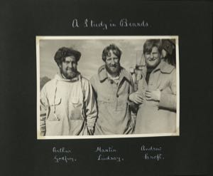
The British Trans-Greenland Expedition of 1934 crossed the Greenland ice cap from west (near present day Ilulissat) to east, sledging over 1000 miles with no outside support. The goal was to explore a 350-mile stretch of the East Greenland coast between Scoresby Sound (Kangertittivaq) and Mt.Forel, creating the first map of that area, and establishing for the first time the altitude of the interior of the ice cap and of what was thought to be the highest peak in the Arctic. Martin Lindsay led the expedition, with Andrew Croft as photographer and dog handler, and Arthur Godfrey responsible for navigation and survey.